

We’ll be ringing in the new year with rain and normal temperatures for this time of year.
So says Environment Canada meteorologist Armel Castellan.
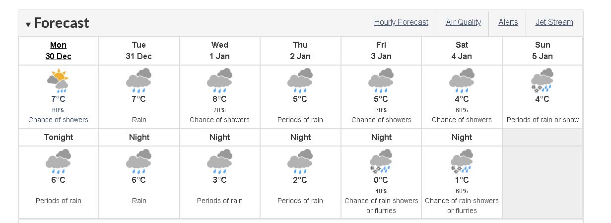
Castellan said that while the outer coast of Vancouver Island will see over 100 millimetres of rain, the east coast will also see its fair share of the wet stuff.
He expects rain to start falling tonight and into the final day of 2019.
“If it’s a full 30 millimetres, it’s going to definitely feel like a fairly wet stretch and then certainly almost triple that amount over on the outer coast,” Castellan said.
Castellan expects it to rain off and on over the next few days, with a second burst of precipitation into the weekend as another system moves in.
“It’s kind of like a two-and-a-half day event, mostly rain for the south coast, and then it looks like it will taper off a little bit,” Castellan said. “We do have a little bit of respite in store for the second week of January but certainly for the next week or so, we have a continued active stretch (of precipitation).”
Watch for Friday night and into Saturday, however. That’s when there’s a threat of snow flurries across the region, according to Environment Canada’s forecast.
Castellan said the soggy stretch makes up, somewhat, for an extraordinarily dry November and first part of December, especially in the central island including the Comox Valley and Campbell River.
“We’re looking at trying to catch up those rain totals for what is our rainiest time of year,” Castellan said.
It’s also been a warmer-than-usual December, according to Castellan: “Some locations, (it’s been) almost two degrees warmer than normal so far this December for the south coast. I would say that is a big part of it.”
And while it’s been a warm late fall and early winter, Castellan said it’s not a La Niña year.
“We have, however, warmer-than-normal sea surface temperatures well offshore,” he said. “It’s kind of the Blob 2.0 at this point, and it’s many thousands of kilometres across and certainly will probably be eroded somewhat through this active stretch of weather, through the winter.”
He said it should be interesting to see how it plays out with our local weather, because having temperatures one-and-a-half to as many as three degrees warmer than normal over the ocean, does play a role on coastal weather.