We’re getting a little taste of summer this week.
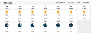
The forecast calls for straight sunshine and temperatures hovering between 15C and 18C in many parts of Vancouver Island and the Sunshine Coast.
Environment Canada meteorologist, Lisa Erven, says a ridge of high pressure is sitting on top of the region and isn’t going anywhere.
“It’s coming up from the southwest which means it’s bringing a very mild air mass with it, so as we go through the week, we’re going to see temperatures climb by a degree or two each day and getting into upper-double-digits for many communities across Vancouver Island and the Sunshine Coast.”
If the ridge holds, we could hit 21C in places like Campbell River and Courtenay by Sunday, which will flirt with record highs for April 18th.
Regardless, Erven says temperatures will rise to two-to-five degrees above normal for this time of year.
Looking past this week, you might be able to put away your winter coat. Erven says modelling into the last week of April shows much of B.C. remaining warmer than normal.
“And then as we get into the first half of May, the long-range forecast is hinting towards above-normal conditions or near-normal conditions for Coastal B.C.”


